Posts

Bhairabkunda

Image
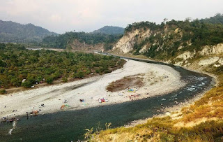
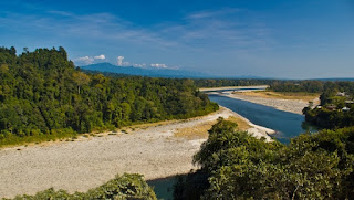
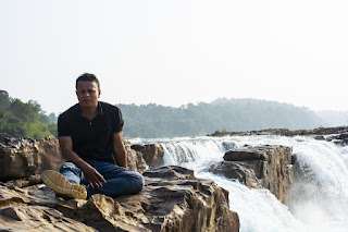
  Bhairabkunda It is place as if it is set in a canvas perfectly painted with all the colours of nature. A popular picnic spot and owing to its calmness and serenity, the place is visited by couples and families alike. Bhairabkunda is located in Udalguri district in Assam at an elevation of 703 metres, and is close to the Bhutanese town Daifam. It is on the border of Arunachal Pradesh and Bhutan and a must-visit for all. The Bhairabi River and the Jampani River, which originate in Bhutan merges here to form River Dhanshiri and forms a lovely view to behold. This is one of most important tributaries of River Brahmaputra and also has a dam. It is in the shape of a kunda, which means worshipping place of Shiva and that is where the name Bhairabkunda came from. Popular Things to See and Do in and Around There is a famous Shiva temple nearby and is visited by devotees all year round. Geographically, the temple is a part of Bhutan though it can be visited by Indians. Daifam, the Bhut

Bogamati Baksa

Image
  Bogamati Baksa A popular White-Water Rafting spot since 2015, Bogamati is located at the foothills of Bhutan in the Baksa district of Bodoland Territorial Region of Assam. Off-beat cycling, ziplining of 450 meters across the bank of river Barnadi, night camping, jungle hike, rappelling are other activities available at Bogamati. Located near the Indo-Bhutan border, Bogamati lies entirely in the newly created Baksa district in Assam. Covered with dense forest, this has become a famous picnic spot for locals and travelers alike. Bogamati is beautiful and is located on the mouth of Barnadi River. The scenic view of the Bhutan Hills is what attracts people to this place. POPULAR THINGS TO DO & SEE AROUND The most popular tourist attraction of Baksa is Manas National Park, which is an important tourist destination in entire Assam. It has different species of animals and plants in abundance. It’s a paradise for bird watchers as well and many migratory birds visit this place dur

Bhalukpung, Sonitpur

Image
  Bhalukpung, Sonitpur: In the Indian state of Arunachal Pradesh, Bhalukpong is a small town located in the foothills of the Himalayas. In the Kameng district of Arunachal, this hill station is situated and is also the headquarters of this circle. This place has an altitude of 213 m and is connected to Tezpur, which is only 52 km away. There is also a hill station and tipi, which has one of the largest orchid rooms, near places like Bomdila. The Kameng rivers that pass through the city are one of Bhalukpong's main attractions and you can spend time sitting next to the water. Bhalukpong is on the way to some of Tawang and Bomdila's most popular destinations, but it also has its own beauty and charm. The place has a thick forest linked to the game sanctuary Pakhui. There are several activities in the area that you can enjoy, such as river rafting, hiking, angling, and fishing, etc. There is also a fort called Bhalukpong Fort, although it is now in ruins and was built on the b

North Sikkim

Image
  North Sikkim : A land - where heaven touches the earth, the ambience creates mystery, a landscape dominated by elements, silence can be heard, vision tends to travel beyond the horizon, soul starts meditating- unknowingly, the mind gets rejuvenated; and land that makes you bow. North Sikkim is the northern district of Sikkim. Mongan is the district headquarter of the district. At an altitude of 3950 ft, the town is located at a distance of 65 km from Gangtok, the state capital. Tourists need special permits to visit North Sikkim beyond Mangan. The area can be visited only as part of an organized tour. The road from Mangan goes straight to Chungthang, another major town of North Sikkim. At 5,600 ft. Chungthang is 95 km from Gangtok. From here the road bifurcates. The road to the left goes to Lachen and the road to the right reaches Lachung. Lachen is the base from where tours to Gurudongmar Lake and Chopta Valley is organized. Lachung, on the other hand, is the base for your tours

All About Deepor Beel, Assam's Only Ramsar Site

Image
  All About Deepor Beel, Assam's Only Ramsar Site The 4.1-square kilometre wetlands of Deepor Beel, the state's only Ramsar site, has around 200 species of birds and 70 species of migratory birds The Deepor Beel Wildlife Sanctuary, in the Kamrup district of the lower Brahmaputra valley, is a perennial freshwater lake on the outskirts of Guwahati, Assam. The state's only Ramsar site (declared in 2002) and a well-known tourist spot, the Deepor Beel is also the only central storm-water storage basin for Guwahati. A Ramsar site is a wetland of international importance under the Ramsar Convention, an international treaty signed in 1971 in Ramsar in Iran.   For One And All Covering 4.1 square kilometres, the Beel, which means "lake" in Assamese, is home to residents and migratory birds and a site to spot herds of Asiatic wild elephants, that are attracted to the lake's aquatic vegetation. They come to the beel from the four elephant corridors of the region, in the R

Rang Ghar

Image
  Rang Ghar: It  is known as  first Ampitheatre or first Pavilion of Asia . It was built by  Swargadeo Promotta Singha  in the year 1744 A.D. Its shape is octagonal at base. The building has two storeys. At the roof of the structure is shaped like an inverted royal Ahom long boat where there are the projecting heads of two small  MAKARAS  or  JALAHASTIS  facing reverse towards north and south. The  Rang Ghar  was built specially for enjoyment of recreational/sports activities by the royal families and public of the Ahom dynasty. Many of the arched entrances have retained little more than their brick framework, with mere vestiges of sculptural adornments here and there.  The adjoining field, known as  Rupohi Pothar , wore a festive look when games like  bull-fight, cock-fight, elephant fight, wrestling, etc ., were held on different occasions during the Ahom rule.  Rang Ghar , besides standing as the royal pavilion, also contributed in spreading the games to different parts of the

Panimoor waterfall

Image
  Panimoor waterfall : In the North Cachar Hill District of Assam, there is the waterfall of Panimoor which is a famous tourist spot. Situated about 120 km away from Haflong, the Kopili River is obstructed by stones, but yet it turns into a gushing milky white waterfall at this spot called Panimur and is indeed an ethereal beauty. The panoramic view of the scenery attracts a number of nature lovers and photographers into this place. There is a Forest Inspection Bungalow in this place, which can house a few tourists but needs to be booked in advance, especially in the tourist season. Panimoor is the only hill station of the district, and thus, favoured by a number of tourists, especially during winter and spring. The Panimur fall also causes flood in the lower lands during the monsoons. POPULAR THINGS TO DO & SEE IN AND AROUND The Kapili River has been referred to as the “happy damsel” in a song by the great Assamese singer Bhupen Hazarika. However, the Kapili River shows its wi