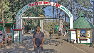
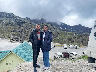
Posts

Showing posts from April, 2024

TAWANG

Image
  TAWANG Tawang is a town situated at an elevation of approximately 3,048 metres (10,000 ft) in the northwestern part of Arunachal Pradesh of India. The town once served as the district headquarters of West Kameng district, and became the district headquarters of Tawang district when it was formed from West Kameng. Tawang town is located approximately 555 kilometres (345 mi) from Guwahati and 320 kilometres (200 mi) from Tezpur. Tawang has an average elevation of 2,669 metres (8,757 ft). Tawang was historically part of Tibet inhabited by the Monpa people. The Tawang Monastery was founded by the Merak Lama Lodre Gyatso in 1681 in accordance with the wishes of the 5th Dalai Lama, Ngawang Lobsang Gyatso, and has an interesting legend surrounding its name, which means "Chosen by Horse". The sixth Dalai Lama, Tsangyang Gyatso, was born in Tawang.Tawang Monastery was founded by the Mera Lama Lodre Gyasto in accordance to the wishes of the 5th Dalai Lama, Nagwang Lobsang Gyatso. It

Manas National Park

Image
  Manas National Park Manas National Park is one of the most beautiful and unspoiled wildlife habitats in the world located at the foothills of the Bhutan-Himalayas in Assam. Manas National Park is a unique biodiversity landscape where you can only find a biosphere reserve, project tiger reserve, elephant reserve and a natural heritage. Manas National Park with an area of 500 sq. kms is home to over 20 endangered species including the Royal Bengal Tiger, rare and endangered endemic wildlife like the Assam roofed turtle, hispid hare, golden langur and the wild water buffalo. The last population of pygmy hogs survives in the wild of Manas and nowhere else in the world. It is contiguous with Royal Manas National Park in Bhutan. Things to do Manas National Park offers you a myriad of activities that include the jeep safari with a bouquet of memories to cherish for lifetime. Jeep safari is the perfect way to explore the park as one can witness wild animals from a safe distance. A jungle tra

Surya Pahar

Image
  Surya Pahar, 130 kilometers from Guwahati city, Assam, bridges a gap of over 2000 years of history of Northeastern India. A stone throw from the majestic Brahmaputra river, and unknown to the prying eyes of archaeologists until 1960, the land hid an epoch beneath its heart. Surya means Sun and Pahar means Hill—the nomenclature suggests this site was perhaps a place of worship of the Sun God. Spread out over 54 acres of land, the area continues to baffle archaeologists. A series of excavations have revealed a stunning past: The area was a confluence of three faiths—Buddhism, Jainism, and Hinduism—in different periods. How these three religions ended up at the same place is still a mystery. Hiuen Tsang, the Chinese traveler who had visited the ancient city of Kamarupa, mentioned nothing about the place. Sculptures, stupas, stone ruins, and exalted folklores are strewn across the slopes and foothills of Surya Pahar Upon entry, towards the left, lies an ancient pond and the newest excava

Kynrem Waterfalls

Image
  Kynrem Waterfalls At a distance of 17 km from Cherrapunji, Kynrem Waterfalls is a stunning falls located near Cherrapunji in East Khasi Hills district of Meghalaya. Situated inside the Thangkharang Park, it is the 7th highest waterfalls in India and among the popular places to visit in Cherrapunji. Falling from a height of about 305 m (1,001 feet), Kynrem Falls is one of the highest waterfalls in Meghalaya that cascades in three levels from the top of a hill. Like many other waterfalls of the region, the Kynrem Falls, too, flow in their full swing only during the months of Monsoon, and it is thus recommended to visit the falls just during Monsoon. Usually, the tourists can get the best views of this waterfalls from a lookout deck within the Thangkharang Park, which was a peaceful little botanical garden containing some benches and picnic areas for relaxing. Situated 7 km further down from Thangkharang, there is a viewpoint on the road connecting Cherrapunji to Bangladeshi Border offe

Solophok Chardham in Sikkim

Image
  Solophok Chardham in Sikkim Solophok Chardham was built to promote Eco and Village tourism and Religious Tourism. Among the top attractions in the state, this site is visited by national as well as foreign tourists. Located at a distance of about 5 km from Namchi in South Sikkim, the complex is built on the top of Solophok hill and covers an area of 7 acres. Being a pilgrimage and a cultural center, Chardham of Namchi has an 87 feet tall statue of Lord Shiva seated at Solophok Hill. Another highlight of the center is the replicas of 12 Jyotirlingas of Lord Shiva. Chardham yatra is one of the most revered pilgrimage journeys in Hinduism and comprises four religious destinations, namely, Dwarka (West), Puri (East), Badrinath (North), and Rameshwaram (South). Solophok Chardham also has models of these places so that the visitors can pay their reverence. Solophok Chardham in Sikkim is distributed mainly in 4 parts - i) Statue of Lord Shiva with 12 Jyotirlingas, ii) Chardham, iii) Sai Bab

Tsongmo Lake or Changu Lake

Image
  Tsomgo Lake, also known as Tsongmo Lake or Changu Lake, is a glacial lake in the East Sikkim district of the Indian state of Sikkim, some 40 kilometres (25 mi) from the capital Gangtok. Located at an elevation of 3,753 m (12,313 ft), the lake remains frozen during the winter season. The lake surface reflects different colours with change of seasons and is held in great reverence by the local Sikkimese people. Buddhist monks prognosticated after studying the changing colours of the lake.After the winter season ends in middle of May, the periphery of lake has scenic blooms of flower species of rhododendrons (the state tree of Sikkim), primulas, blue and yellow poppies, irises and so forth. Also seen in the precincts of the lake are several species of birds including Brahminy ducks. Wildlife seen includes the red panda. Tourist attractions at the lake site include joy rides on decorated yaks and mules where kiosks offer variety of food and drinks. There is also a small Shiva temple on t

Nathu La

Image
  Nathu La, one of the highest motorable roads in the world, is a mountain pass in the Himalayan peaks that co-joins Sikkim and China. Situated on the Indo-Tibetan border 14450 ft. above sea level, Nathu La is one of the most important Himalayan passes in the country. Nathu means 'listening ears', and La means 'pass'. Nathu La is one of the three open trading border posts between India and China and is famous for its picturesque beauty and beautiful environment. The temperature here remains low for most parts Located on the Old Silk Route, Nathu La Pass connects Sikkim to China’s Tibet Autonomous Region. It was sealed for almost 4 decades after the People’s Republic of China suppressed a Tibetan uprising in 1959. However, when the former Prime Minister of India, Atal Bihari Vajpayee visited China in 2003, talks to open the strategic route were resumed. The Nathu La Pass was reopened in 2006 and since then, it has served as an official Border Personnel Meeting(BPM) Point

Mawphlang Sacred Groves

Image
  Mawphlang Sacred Groves An untouched forest that is the soul of Khasi culture, Mawphlang is home to the most celebrated of all the ‘law-kyntang’ or ancient sacred groves of Meghalaya. For centuries now, Khasi customs and traditions have been woven into the land and the forests. One of these forests still retains its significance today – the Sacred Groves of Mawphlang. Visitors are not allowed to take anything away from this hallowed forest, not even a pebble or a twig. The dark canopy above and soft humus under your feet will transport you to a primaeval age – a contrast from the green meadows and sprightly pines that dominate the surrounding hills. Apart from rare plants, mushrooms, and trees, the forest is also home to old coronation and sacrificial sites. This was where Khasi kings and ceremonial leaders (Ki Lyngdoh) had their meetings and new chiefs were anointed here. The sites are marked with monoliths, still reminders of a dignified past as the forest creeps around them. The S

Phe Phe Falls

Image
  Phe Phe Falls Another falls that leaves you mesmerized, located in Jaintia hills, while heading towards Krangsuri Falls, is Phe Phe or Phea Phea falls. It is the two-tier waterfall, and it has its name from the Jaintia word, which translates into Paradise. This fall is no less than a paradise, and what makes this waterfall of Meghalaya thrilling is its location. The Phe Phe falls is located in the backdrop of the blue sky and the ranges of the hills, layered with light and shadow. Visiting the falls will give you the perfect feeling of entering heaven's realm. This place is hidden even to locals. How to Reach The impressive Phe Phe waterfall is located 20 kilometers from the Jowai toward Krangsuri Falls. To reach the fall, you can take sumo to Jawai from any taxi stand in Shillong. The trek will be around 2-3 hours, and one must cross the small river by kayak to reach the falls. The terrains are plain; from there, it descends steeply to get to Paradise falls. Overnight camping is

The Jagannath temple

Image
  The Jagannath temple in Puri, Odisha, is one of the holy char dham abodes of God that are considered to be extremely auspicious for Hindus to visit (the others are Badrinath, Dwarka, and Rameshwaram). If you don't let money-hungry Hindu priests (locally known as pandas) mar your experience, you'll find that this massive temple complex is a remarkable place. However, only Hindus are allowed inside. Location Puri is just under two hours south of Bhubaneshwar, Odisha's capital city. The nearest airport is situated in Bhubaneshwar. There are frequent buses and trains from Bhubaneshwar to Puri. Puri's railway station also receives long distance trains from all over India. Temple History and Deities Construction of the Jagannath temple dates back to the 12th century. It was initiated by Kalinga ruler Anantavarman Chodaganga Dev and later completed, in its current form, by King Ananga Bhima Deva. The temple is home to three deities -- Lord Jagannath, his elder brother Balabh

Sun Temple

Image
  Sun Temple The Konark or Konarak Sun Temple is dedicated to the Hindu sun god Surya, and, conceived as a giant stone chariot with 12 wheels, it is the most famous of the few sun temples built in India. It is located about 35 km northeast of the city of Puri on the coastline in the state of Odisha (earlier Orissa). It was built c. 1250 CE by King Narasimhadeva I (r. 1238-1264 CE) of the Eastern Ganga dynasty (8th century CE - 15th century CE). The temple in its present state was declared by UNESCO a World Heritage Site in 1984 CE. Although many portions are now in ruins, what remains of the temple complex continues to draw not only tourists but also Hindu pilgrims. Konarak stands as a classic example of Hindu temple architecture, complete with a colossal structure, sculptures and artwork on myriad themes.

samdrup jongkhar

Image
  samdrup jongkhar Bhutan, a place where happiness has made it its permanent abode. It is also a country where many places have existed since olden times. Samdrup Jongkhar is one such place. Besides being a top tourist attraction in Bhutan, it is also famous for being one of the oldest towns in Bhutan. Visit it on any particular day, and you will see it bustling with shopkeepers, hawkers and customers eager to lay their hands on something exciting. It shares its borders with the state of Assam in India and is popularly known as the gateway to eastern Bhutan. Most of the towns in this country are known for their differences in elevation, and this busy little town is no exception. It enjoys an elevation difference of 200m to 3500m. Back in time, British political officers stationed in Sikkim would use the route from Samdrup Jongkhar to enter Bhutan. Another interesting historical fact is that at one point in time, this place functioned as a main trading center for the Bhutanese. Even tod

Garden Of Caves

Image
  Garden Of Caves Located in Cherrapunjee, Meghalaya in the beautiful Northeast region of India, the Garden of Caves is a breathtaking natural wonder that is not to be missed. This 2.5-hectare park is surrounded by lush greenery and thick forests, providing visitors with an immersive experience of nature that is truly unforgettable. ​ As you stroll through the winding paths of the park, you'll encounter ravishing caves, sparkling cascades, and magnificent seasonal waterfalls. The caves, formed by the natural erosion of limestone rock, are illuminated by the beams of sunlight that filter through the emerald greenery, creating a magical and mystical atmosphere. The cascades and waterfalls of the Garden of Caves are equally impressive, providing visitors with a refreshing respite from the hot and humid weather of Cherrapunjee. The surrounding flora and fauna create a serene and peaceful environment, allowing visitors to relax and recharge in the lap of nature. ​ Some of the main attra

Noh-khali-kai Fall

Image
  Noh-khali-kai Fall At 335 meters, Nohkalikai which literally translates to ‘Jump of Ka Likai’ is the highest plunge waterfall in India and the 4th highest in the world. The tragic tale behind the name tells the story of a Khasi damsel called Likai who lived in the village of Rangjyrteh upstream of the waterfall. Widowed with a young daughter, Likai remarried in the hopes of providing a father figure for her child. Likai took over her dead husband’s job of a porter carrying loads of iron to Shylet and spent most of her day working. What little time she could spare back home was spent showering her young daughter with her attention and love. The new husband was envious and resentful of the fact that Likai paid more attention to the child than him and decided to take matters into his own hands. One day while Likai was off to work, the husband chopped the child into pieces and cooked her flesh throwing away the head and bones but forgot one of the severed fingers in the kwai (betel nut)